I am optimistic about climate change, not only because the 2018 United Nations Climate Change Conference has shown that mankind is waking up, or because in March, a 17-year-old girl was able to mobilize an estimated 1.6 million high school students in 125 countries around the world to protest the present inaction about global warming. And I’m particularly optimistic because of the contributions our technology—the monitoring capability of the process control profession—are making.
Consider the fact that our scientific modeling was able to convincingly and accurately predict the future and thereby give us time to fix things. Consider that, based on measuring only a few millimeters of ocean level rise and less than a degree of global temperature rise, our models were capable of predicting that this process, if left uncontrolled, spells disaster for the future. This is a fantastic achievement!
Here I will focus on the accuracy of two additional measurements: the level of the oceans and the changes in the mass of the ice on our planet as the polar and glacier ice formations are melting. Accurate measurements of these variables are important not only to resolve the debate between denialists and alarmists, but also to establish the dynamics of the global warming process so we can more accurately predict its speed, time constants, rate of rise and tipping points.
Accurate measurement of ocean levels must take into account that both the sea and the land experience vertical motion. Land can move vertically due to glacial and tectonic processes. The sea level is affected by tides caused by the gravitational forces of the earth-moon and earth-sun systems, or by "weak tides" (also called meteorological tides) generated by winds. Because this monitoring involves accurate measurements on the scale of millimeters, not only accurate detectors, but also sophisticated models are needed to correct the globally observed mean sea levels for the effects of regular and meteorological tides.
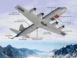
Figure 1: NASA's P-3B four-engine turboprop is equipped with radar and laser altimeters to measure annual changes in thicknesses and movements of ice. Source: www.nasa.gov/mission_pages/icebridge/instruments/p3b.html
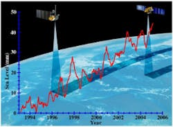
The level models depend on two measurements. One is the relative sea level (the height of the water relative to the land), which is corrected for any earth movements. The second measurement is provided by satellite altimeters, which measure the distance between the ocean's surface and the center of the Earth.
Accurate altimeters
Laser altimetry: By the 1990s, laser altimetry from aircraft had revealed thinning of the ice sheets on Greenland’s coastal margins [Abdalati et al., 2001] and later surveys, using NASA’s Airborne Topographic Mapper, showed a further increase in that thinning [Thomas et al., 2009]. NASA's P-3B is a four-engine turbopropequipped with radar and laser altimeters (Figure 1). Researchers use highly sophisticated airborne instruments on these retrofitted aircraft to measure annual changes in the thicknesses and movements of the ice.
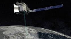
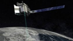
Satellite altimetry: A new NASA satellite, ICESat2 (Figure 2), was launched in September 2018. It is expected to gauge future changes of the Greenland and Antarctic ice sheets at an accuracy of the width of a pencil. In the Arctic, NASA's Icebridge operation studies the effect of the polar ice on the Earth's climate. ICESat2 (short for Ice, Cloud and land Elevation Satellite), measures the time it takes for laser beams to travel from the satellite to Earth and back. Based on that information, scientists can accurately calculate the height of glaciers, sea ice, etc.
Figure 2: NASA's ICEat2 (cloud and land elevation satellite) accurately measures ice sheet thickness at an accuracy of the width of a pencil. Source: www.click2houston.com/news/national/nasa-to-launchlaser-device-into-space-to-measure-earths-polar-ice
This, the largest airborne operation to survey polar ice, is designed to plug the gap between ICESat, which ceased functioning in 2003, and the launch of ICESat2 in September 2018. Researchers used data from these yearly surveys to determine the rate of the melting of the ice and found that it was increasing [Thomas et al., 2011]. The study also relied on data from NASA’S Airborne Topographic Mapper, as well as the University of Kansas ice-depth sounder, both of which had made almost yearly surveys since 1991 of the Jakobshavn Isbrae glacier in Greenland and, since 2002, of the Pine Island glacier in Antarctica.
The early 1980s saw the very first attempt to measure ice sheet thicknesses using satellite radar altimetry, with observations of only limited parts of Greenland and Antarctica [Remy and Parouty, 2009]. The ice thickness on Greenland is about a mile, on Antarctica, it is about 3 miles. Since then, however, altimetry technology has advanced a great deal and became an important means of determining ice sheet and glacial mass balance, measuring the gains and losses in ice mass. While the primary measurement is by laser altimetry (ICESat2), with high accuracy and a very small footprint, radar altimetry was also used in the ESA mission's CryoSat-2 work.
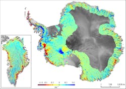
Figure 3: These photos from NASA's Ice, Cloud and Land Elevation Satellite reveal areas of dynamic thinning (red) in Antarctica and Greenland (left). Source: https://sealevel.nasa.gov/understanding-sea-level/global-sea-level/ice-melt
Radar interferometry: Satellite synthetic aperture radar interferometry techniques measure the speed at which ice streams move, as well as the position of the grounding line, which separates ice grounded over bedrock from ice floating on the ocean, as it breaks off from the same ice stream. One example of the power of this technique was the measurement of the retreat of Antarctic glaciers [Rignot et al., 2014]. The researchers used data from the ERS-1 and 2 synthetic aperture radar to measure the rapid retreat of the glaciers in West Antarctica. The study produced color-coded maps (Figure 3) of the velocity of recession for the glaciers, which showed movement of the glacial grounding lines.
Satellite gravimetry: The advent of gravimetric measurements with the twin Gravity Recovery and Climate Experiment (GRACE) satellites in 2002, along with more recent deployment of floating Argosensors, opened the way to closure of the sea level budget—that is, when the sum of observed ocean mass and density changes equals total sea level change [Leuliette and Willis, 2011].
GRACE measures changes in water mass, including terrestrial storage in the form of groundwater, rivers, snow and ice, and mass changes within the ocean itself, as well as the movement of water between land and ocean (Figure 4).
Figure 4: The advent of gravimetric measurements with the twin Gravity Recovery and Climate Experiment (GRACE) satellites in 2002, along with more recent deployment of floating Argosensors, opened the way to closure of the sea level budget (when the sum of observed ocean mass and density changes equals total sea level change). Source: http://ossfoundation.us/projects/environment/global-warming/sea-level-rise
Early attempts didn’t achieve closure of the sea level budget for four-year trend lines [Willis et al., 2008, Chang et al., 2010], leading to concerns about possible instrument drift. More recent efforts, however, led to reports of closure for more extended periods, including a NOAA[4] report covering 2005 to 2013 ("The Budget of Recent Global Sea Level Rise, 2005-2013," by Eric Leuliette).
Notes
- Some of the following paragraphs are taken from a NASA document at https://sealevel.nasa.gov/understanding-sea-level/global-sea-level/ice-melt.
- ESA's (European Space Agency's) CryoSat is Europe's first spacecraft dedicated to the study of ice. Its 1000-day mission is to precisely measure variations in the thickness of polar ice sheets and floating sea ice.
- European Remote Sensing satellites
- US Dept of Commerce, National Oceanic and Atmospheric Administration (NOAA)
